-

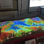
- SimTable set up with elevation data.
-
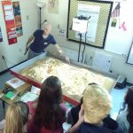
- Instructor demonstrating functions of the SimTable.
-
- Freebies for students at our GIS Extravaganza.
Kurt Butefish and I would like to extend a special thank you to Cassie Bates at Centennial High School for inviting us to spend the day with her AP Human Geography students to promote geospatial technology. Cassie’s students are learning about food deserts in class so we used ArcGIS Online to map out grocery store data in Williamson and Davidson Counties and find areas that are currently underserved. Students were especially engaged when we used the Living Atlas layers for projected population growth to identify areas in their community where more services (like schools and grocery stores) will be needed as the Nashville area continues to grow. We also had students examine socioeconomic data of their neighborhoods using the ESRI Tapestry data sets. They were amazed and horrified by how well the data represented their families.
Students were also able to utilize our new SimTable to learn about how geospatial technology is used to plan for natural disasters like wildfires, toxic plumes, and floods. Despite our best efforts, it was a real struggle to try and keep our simulated wildfire west of Franklin from spreading to the city despite the use of air tankers, helicopters, dozers, and hand crews.